Know Your Lows
There are three major types of lows: tropical lows, mid-latitude lows, and cut-off lows. It is important to understand the differences between them.
Tropical lows
Living in the belt of tradewinds, these are also known as tropical depressions, tropical cyclones, hurricanes, and typhoons. They are seasonal and travel east to west in the trades. The GFS weather model dramatically underestimates the strength of tropical lows, but it predicts their location and movement reasonably well. It is critical to receive hurricane advisory forecasts for accurate prediction of their strength and movement.
Tropical lows derive energy from the warmth of the oceans and the release of latent heat energy from the formation of the clouds. Cold, dry air can weaken a tropical low. A concentration of thunderstorms over water temperatures of 80°F (27°C) or warmer is the first sign of a tropical low forming. If there is a jet stream or other strong wind aloft, tropical lows will not form because thunderstorms need to develop vertically. Jet stream winds or wind shear will tear them apart.
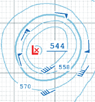
Since the jet stream is usually not present near a tropical low, the low’s movement can be erratic and less predictable than a mid-latitude low. A tropical low is much smaller in size than a mid-latitude low, frequently only 400-500 miles across, though the biggest ones might be twice that size. The strongest winds will be found within 25-50 miles of the center. Barometric pressure gradient is also much less than with a mid-latitude low.
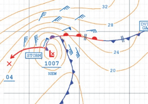
The most dangerous side of a tropical low is the “right side” in the northern hemisphere. If the tropical low is moving east to west, this would be the north side; if it’s moving from south to north, this would be the east side. Winds are strongest over a much larger area and the seas are also largest on the “right side.” You should never try to cross in front of a tropical low.
The North Atlantic and northeast Pacific hurricane season runs from May to November, with peak activity from late August through to early October. A low is designated as a tropical depression as soon as a defined low-pressure circulation exists (rather than just a cluster of thunderstorms) and as long as sustained wind speeds are under35 knots. When sustained winds are 35 knots or higher, it becomes a tropical storm (and gets a name). That same low becomes a hurricane when sustained winds are 64 knots or higher over any part of it. In the western North Pacific, tropical storms are called tropical cyclones; they are also given names.
Note: This is an excerpt from the Safety at Sea Guide