Know Your Lows
There are three major types of lows: tropical lows, mid-latitude lows, and cut-off lows. It is important to understand the differences between them.
Mid-latitude Lows
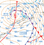 Mid-latitude Lows are the low pressure areas we most frequently experience between latitudes of 30° to 60° (both north and south, and they are very different from tropical lows. These are the traditional low pressure areas that move west to east and have attached warm and cold fronts. Newly formed lows have small and intense centers, while old lows can have broad centers with light wind. The barometric pressure gradient is much greater than it is in a tropical low.
Mid-latitude lows travel parallel to the isobars in the cold sector (the area between the cold and warm fronts on the equator side of the low).
They move at about half the speed of the 500mb upper level wind in their vicinity. They are reasonably well forecasted by the GFS weather model. Energy for a mid-latitude low comes from the mixing of cold and warm air, such as when east coast storms move off the land and over the ocean. The greater the temperature contrast, the stronger the low will become. This is why the strongest lows in the northern hemisphere occur from late October through December, and again from February through April; the ocean is still warm, while approaching air can be very cold. In the northern hemisphere, there will be a warm front east of the low, where east winds shift to south as the front passes. There will also be a following cold front, where south winds shift to west and northwest as the front passes.
Warm currents like the Gulf Stream, Kurishio, East Australian (EAC), and the Agulhas can increase temperature contrast, which is why they are breeding grounds for strong lows. The large size of these storms – 3000- 5000 miles across – makes them very difficult to avoid completely.
As cold and warm air mix within the low and the air mass becomes more homogeneous, the low will weaken and the winds will diminish. This is the occlusion phase of the storm’s life cycle. The leftover seas can still be large, however, which creates a “washing machine” eff ect: little wind, but agitated seas.
Note: This is an excerpt from the Safety at Sea Guide